
What is an Orthomosaic Map and How is it Created?
In very simple terms an orthomosaic is a precise, detailed overhead map. Many of us use orthomosaic maps daily. If you used Google or Bing maps, then you worked with an orthomosaic map. Google and Bing Maps are generated from photos captured by planes and satellites. These maps provide a unique way to view an area and they provide value to construction and landscape projects, agricultural operations and even processes such as city or town planning.
In this post I will cover:
- What an orthomosaic map is.
- How orthomosaic maps are different from basic overhead imagery.
- How an orthomosaic is created.
- Understanding the quality issues of an orthomosaic map.
What is an Orthomosaic Map?
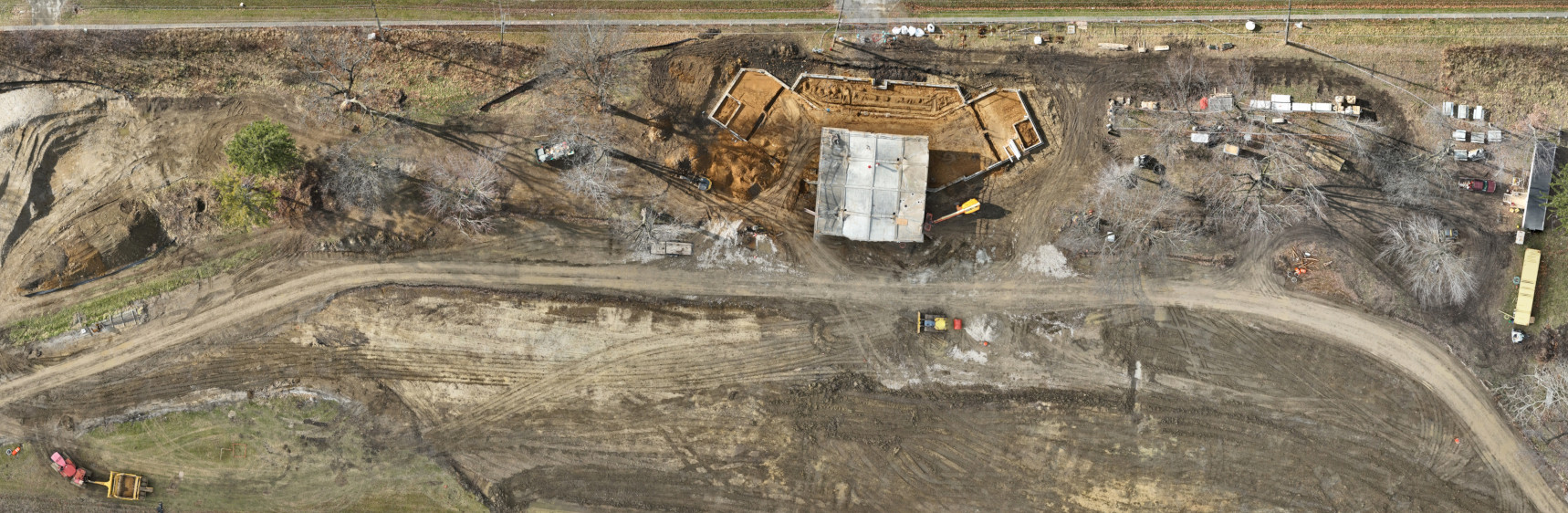
Orthomosaic maps, or orthomosaics, are precise, high-resolution overhead maps. These maps are created from many images taken in a very specific pattern and are stitched together to make one large picture. They offer a comprehensive aerial view of project areas, such as construction sites or landscaping projects. These maps can provide a high-level overview of a large area yet still offer drill-down capability to potentially centimeter-level details.
Orthomosaic maps are generally two-dimensional but can be three-dimensional. Two-dimensional maps are more common, providing an overhead view of a target area. Three-dimensional maps create a three-dimensional model and allow a viewer to move around the map in all three dimensions.
Most of us have worked with orthomosaic maps. If you have ever used Google or Bing maps, then you have experienced an orthomosaic created from many images taken from satellites and planes.
How Orthomosaic Maps Differ from Basic Overhead Imagery?
Orthomosaic maps are more than just overhead images. They are much more than a snapshot from a satellite, plane, or drone. Orthomosaic maps consist of many images captured from an aerial platform (such as a drone), which are heavily processed and stitched together to create a detailed and geographically correct image.
Note: There are 3D orthomosaics, which can be created from images or LIDAR data. 3D orthomosaics are three-dimensional models created from the captured data. While they are very interesting for architectural, construction, and landscaping purposes, they are not as common a deliverable in drone projects. For this post, we will focus on 2D orthomosaics, and the term “orthomosaic” generally refers to these more common maps.
Orthorectification
Images used to create an orthomosaic are orthorectified. Orthorectification is the process where software corrects distortions (such as parallax) to produce a true top-down image. When the camera is pointed directly downward, a good top-down view is achieved. Parallax occurs as structures move further away from the center of the image, causing them to appear to lean. Since an orthomosaic consists of many images, the parallax effect must be corrected. This process involves complex math that we won’t dive into here; suffice it to say that orthorectification fixes leaning structures to create a consistent top-down view.
Mosaicing
Orthomosaic maps are not made from a single image but rather from many images stitched together (or “mosaiced”) to create one large image. With high-quality images and advanced software, individual images blend seamlessly, providing a high-level overall picture while still allowing users to zoom in for more detail. Like orthorectification, the mosaicing process relies on detailed algorithms and math.
Georeferencing
The final key difference is that an orthomosaic map is georeferenced. Each point on the map is tied to a real-world location using a geographic coordinate system. A basic image might only be referenced by a single latitude and longitude, providing only a general location of capture. In contrast, a georeferenced orthomosaic ties many points to a coordinate system, enabling its use alongside other maps and Geographic Information Systems (GIS) such as Esri and QGIS. This results in a much more accurate representation, with georeferencing accuracy often measured in centimeters or meters depending on the data collection systems used.
How is an Orthomosaic Map Created?
Creating an orthomosaic map is a multistep process involving mission planning, data capture, post-processing, and sometimes manual fixes.
Preflight Mission Planning
Preflight mission planning is one of the most critical parts of successfully creating orthomosaics. Key requirements must be determined before any flight:
-
Mission Requirements:
Two key requirements are accuracy and resolution.- Accuracy: How exact must the georeferencing be? Standard GPS typically provides accuracy within 10-30 feet, which may be sufficient for some projects. However, missions requiring centimeter-level accuracy might need RTK or PPK systems.
- Resolution: The level of detail needed dictates the number of images captured and the overall quality of the final orthomosaic.
-
Equipment Selection:
Not all drones are equal. Clear images are essential for orthomosaic maps, which require a stable drone platform and a quality camera. Cameras with mechanical shutters are recommended. Depending on the accuracy requirements, you might use standard GPS or upgrade to RTK/PPK systems. Higher accuracy can be achieved with additional hardware and ground-control points. -
Flight Plan:
Based on accuracy and resolution requirements, the flight plan includes altitude, speed, and a flight pattern designed to capture the target area completely with high overlap for effective stitching. Drone and airspace regulations must be checked, and permissions may be required in controlled airspace. Safety concerns, such as obstructions (power poles, buildings, trees), must also be evaluated.
Mission Flight
When mission planning is done correctly, the flight is usually straightforward. However, weather is an unpredictable factor. Calm, slightly overcast days are ideal; high winds, precipitation, or low light can necessitate postponement.
Onsite, final checks ensure that camera settings and drone speed are optimized to capture sharp images. A basic quality check of the images is performed before leaving the site.
Post Flight Processing
After the flight, image processing (photogrammetry) begins. The images are collected, stored for safety, and then sent to one or more photogrammetry software applications. Photogrammetry involves cleaning up, orthorectifying, and georeferencing the images. Common software systems include PIX4D, DroneDeploy, and RealityCapture.
- For small to medium-sized orthomosaics: A powerful desktop with a GPU may suffice.
- For larger projects: Cloud-hosted systems might be necessary.
The processing can be iterative, with adjustments made to software settings and removal of problematic images to produce the best quality orthomosaic map possible.
Orthomosaic Quality Considerations
While we strive for quality with every orthomosaic mission, it’s important to understand that the final orthomosaic map is the product of a complex process rather than a single, giant image. Orthomosaics are assembled from many individual images, which allows for exceptional detail—often down to the centimeter level—but also means that the final image may not be perfect. It is somewhat of a tradeoff.
Even under perfect conditions, common issues can arise:
- Moving Objects: Cars, people, or other moving objects may appear as partial or ghosted images.
- GPS/Georeferencing Limitations: Environmental factors can occasionally cause slight misalignments, which can generally be fixed in GIS software such as ArcGIS or QGIS.
- Stitching Errors: The software may not perfectly match overlapping areas, leading to minor distortions.
- Environmental Factors: Changing light conditions or passing clouds during the flight can lead to subtle differences in the mosaic’s uniformity and quality.
Another consideration is that progression orthomosaic maps—those captured over time—can exhibit different lighting and tone due to variations in sunlight and its color at different times of the day or year. Post-processing techniques can normalize or reduce these differences, improving the overall consistency of the final deliverable.
Overall, while many orthomosaics achieve an excellent balance of high-resolution detail and geographic accuracy, they represent a composite of multiple images rather than one gigantic, single-capture photograph. This approach enables the rich detail and flexibility required for precise analysis and measurement—even if it sometimes comes with small imperfections that are inherent in the process.
Summary
In summary, orthomosaic maps offer an exceptional way to capture high-resolution aerial imagery, delivering unparalleled detail and precision for construction, landscaping, and more. While the process—from capturing overlapping images to sophisticated post-processing—may introduce minor quality issues, understanding these challenges sets realistic expectations and empowers you to leverage orthomosaics for informed, data-driven decisions. If you have questions about orthomosaic maps or want to explore how these maps can save your business time and money, contact us today to learn more about our tailored solutions.